| Data Updated: |
Tuesday, January 31, 2012 9:25:46 PM |
| Status: |
Confirmed
|
| NOTE: |
Changes have been made to the timeline since originally posting this page. Please note the new times & departures |
| Trip: |
High Shoals Scenic Area |
| Date: |
January 28, 2012
|
| Trip Host: |
Marsha Conner / Jeremy Landers
|
| Location: |
High Shoals Scenic Area
Towns County, GA
Chattahoochee National Forest |
| Cost: |
Carry cash for fuel sharing.
If weather does not allow for a campfire at site, cash for burgers at Creekside Deli after hike (OPTIONAL) – check with your driver and know their plans before riding.
(NOTE: Creekside Deli does not take debit or charge cards – cash only) |
| Difficulty: |
Moderate
The trail is a mixture of easy and moderate – decline into the falls – incline from the falls. |
| Length: |
2.4 Round Trip |
| Blaze: |
Blue |
| Departs From: |
Grace Parish Hall Parking Lot
Quillians Corner Chevron
Other locations can be arranged by contacting Marsha or Jeremy |
| Departure Time: |
9:30am Depart Grace
10:00 am Depart Quillians Corner Chevron
|
| Meals: |
Lunch:
Bring a trail lunch or snacks
Weather permitting we will gather in one of the trail side campsites on our way out to enjoy a small campfire. A small cookstove will be provided for heating water.
Note: If you want a hot beverage at the lunch site, you must carry your own water supply (Water will be put into a pot shared by others so water should be un opened / un used!), beverage mix, and cup/spoon. We will have a source to heat water regardless of the weather, but we will not be carrying other supplies for everyone.
|
| Transportation: |
POV's with carpooling, or drive on own. If you need transportation you can post an email to the hike group email list.
(Always be prepared to drive your own vehicle if necessary. If you carpool, fuel costs should be shared.)
|
| GPS Info: |
High Shoals & Blue Hole Falls Trailhead location - N34º 48.97' W83º 43.62' - Elevation 2880'
|
| USGS Quad: |
|
| Ranger District: |
|
Hike
Schedule: |
9:15am Meet @ Grace Main Parking Lot at Parish Hall to check in, use facilities, arrange carpooling and get ice.
9:30 am Depart Gainesville
9:45 am Be at Quillians Corner, gas up, etc...
10:00 am Depart Quillians Corner
10:45 am Bathroom break at Helen Welcome Center - Snack if desired.
11:30 am arrive at trailhead - safety briefing - begin hike
1:15 pm build fire - have lunch - make hot beverages (see note above regarding meals) - if the weather is not favorable for fire, we will just rest and snack and hike out.
NOTE: We recommend you carry a campstool or insulated pad to sit on at the campsite. The ground will be wet and cold. The rocks will be cold.
With Campfire
2:00 pm Put out fire and hike out
4:00 pm - Appx. time of return to parking area - Dept for Gainesville.
5:30pm - Back to Gainesville area.
No Campfire
2:00 pm Hike out and return to trailhead
4:15 pm Stop at Creekside Cafe' in Cleveland for burgers - Optional
5:30 pm Depart for Gainesville
6:00 pm Back to Gainesville area.
Return to Gainesville as you wish.
* Remember: IT IS PACK IT IN AND PACK IT OUT
When we leave the lunch site area, we will leave it clean.
All times are approximate and are subject to change without notice! Direction of travel is subject to change as well.
|
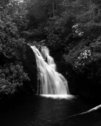
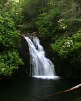
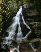
| Trail Description: |
High Shoals Scenic Area is located north of Helen, GA right off Hwy 75. After crossing Unicoi Gap and the AT, you will start down the mountain and just before reaching the bottom, look for a right turn onto FS Road # 283. This FS road is a dirt road and you will have a small ford of the Hiawassee Creek about .2 after you turn onto it. Most vehicles will have no problem with this crossing. Depending on the weather conditions, you could get your car a little muddy though. You will drive 1.3 miles up the FS Road and park on your left at the top of a ridgeline. There may be a sign there naming the High Shoals Scenic Area.
The trail descends for .2 mile, then levels off and proceeds through old growth forest. At .6 mile, there is another decent and you can hear and see High Shoals Creek. This flat, creekside area is popular with campers and this is where we will have a campfire if weather permits. If we have carried wood with us, we will drop it here. The first waterfall, Blue Hole, is .3 ahead. The second waterfall, High Shoals, is .4 ahead. We will explore both waterfalls and then return to the creekside area and either build a fire, and eat, or just rest and eat. Remember to bring your own supplies if you want a hot beverage at this site. We will be able to heat water regardless of the fire.
The hike out will have two short hill climbs, but we will take them very slow and easy. Everyone should be okay with them if they go slow and take their time.
Marsha |
| Trip Notes: |
Please be sure you have read the notes in this briefing and understand the game plan for this hike.
|
| Camping, Cabins, Etc. |
Optional - On Own
There are a few trailside campsites for those who wish to backpack in on thier own. There is not an organized overnight camp for this trip. |
| In Case Of Emergency Forms (ICE): |
Please be sure you have an ICE form for each hiker on file for emergency contact information. The only part of this form that is required to be completed is the personal contact info for each hiker. We think it would be wise to provide the medical information, but that is optional for each hiker. These forms and the envelope they will be sealed in are bright yellow. If you have not turned in a new ICE form, you will need to do so before you hike. You may contact Marsha or Jeremy to obtain a form. Please have these forms filled out before we meet to hike. You can turn them in at the hike site, but it will be best to have them filled out before we gather to hike. |
General
Notes: |
Walk at your own pace! Try to walk with someone when possible and try to stay in sight or sound of the main group which means the lead hikers may need to slow or stop to let the rear hikers catch up. This is a good reason to carry a whistle on you at all times. Lead hikers should stop at all trail intersections to let everyone gather before moving forward.
If you need a potty break while on the trail, just let someone know you are leaving the trail for a few moments and have that person wait nearby until you return. If you should feel ill or become weak while hiking, let Jeremy or Marsha know immediately. Do not push yourself forward on the trail under adverse conditions. One of us will work with you to maintain your safety. If you have any medical concerns that need to be known, be certain a hiking partner or Jeremy/Marsha know about any issues that could require immediate attention.
Carpoolers should share the cost of fuel when returning to their base location.
If you have any questions regarding the logistics for this hike, please contact Jeremy Landers. If you are signing up to hike or have transportation issues, contact Jeremy Landers. More info on our hiking plans can be found at: www.LandersStudions.com/gechike
PLEASE - DO NOT CONTACT THE CHURCH OFFICE REGARDING THE HIKES. THE CHURCH OFFICE DOES NOT HANDLE OUR PLANS NOR ROSTER FOR THIS ACTIVITY. CONTACT JEREMY OR MARSHA DIRECTLY.
HIKE AT YOUR OWN PACE - BUT HIKE WITH A PARTNER OR IN SIGHT OR SOUND OF YOUR GROUP FOR SAFETY.
|
| Links & Ref. |
Trip page from a 2006 hike to the falls! Note the old site design.
Use your browser's Back button to return to this page! |
| Photos |
|
| Map |
|
| Directions: |
From Helen, go north on GA 75 11.3 miles. Turn a very sharp right on Indian Grave Gap Road (FS 283). This road is the first on the right after passing Unicoi Gap. Ford the stream and continue up the bumpy hill. At 1.4 miles from GA 75, the road reaches a level spot and curves to the right. The parking area and trailhead are on the left.
|
Hike Reservations:
Note Corrected Date |
Required
Deadline January 24, 2012.
Marsha Conner
or
Jeremy Landers
770-861-8175
*Special Notice Regarding Hikers Under 18 Years of Age!
|
| Post Trip Review: |
|