|
 |
 |
 |
|
 |
|
Hike Info Page
|
|
|
|
|
|
DO NOT CONTACT THE CHURCH OFFICE
TO SIGN UP FOR HIKES NOR FOR INFORMATION
CONTACT THE HIKE PLANNER DIRECTLY
|
|
|
|
| Trip: |
High Shoals Falls & Blue Hole Falls |
| Date: |
September 16, 2006 (Camping optional Sept. 15th & 16th)
See Below For Details |
| Trip Host: |
Jeremy Landers |
| Location: |
Towns County, GA |
| Cost: |
Carry cash for fuel sharing & camping if you stay over night. |
| Difficulty: |
Moderate - Difficult (Steep coming out) |
| Length: |
2.5 Miles Round Trip |
| Departs From: |
The Grace Center
Unicoi Gap Parking Area
Upper Chattahoochee River Campground |
| Departure Time: |
8:30 AM Grace Center
9:00 AM Upper Chattahoochee River Campground
9:30 AM Everyone Meet at Unicoi Gap Parking Area
9:35 AM Carpool Depart for Indian Grave Gap Road
If you are camping meet at the Upper Chattahoochee River Campground. |
| Meals: |
Bring a sack Lunch |
| Transportation: |
POV's with carpooling
(Always be prepared to drive your own vehicle if necessary. If you carpool, fuel costs should be shared.) |
| GPS Info: |
High Shoals & Blue Hole Falls Trailhead location - N34º 48.97' W83º 43.62' - Elevation 2880'
Upper Chattahoochee River Campground
N/A |
| Trail Description: |
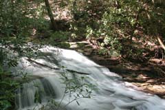
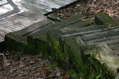
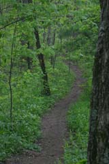
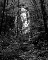
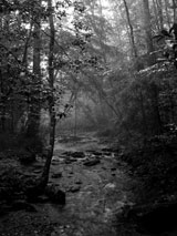
The trail starts in the parking area (an elevation of 2880 feet) to the left of the High Shoals Sign at the top of wooden steps. It quickly turns to the right through a series of switchbacks down to the scenic area . At the bottom of the mountain, the trail follows an old jeep road to a foot bridge on High Shoals Creek. There are campsites on both sides of the bridge. After crossing the creek, the trail turns to the left and parallels the creek past five waterfalls. At 0.9 miles a side trail leads to Blue Hole Falls an observation deck, and a great swimming hole. At 1 mile, another steep side trail leads to High Shoals Falls, about 100 feet high. |
| Notes: |
This trip includes an optional overnight stay at the Upper Chattahoochee River Campground on September 15th and 16th (Campsites are on a first come first serve basis).
If after our hike you are interested in more there are a few other trails in the area. Those camping overnight may want to hike some on Sunday as well.
Watch for more details. |
| Links & Ref. |
http://georgiahikes.com/main.asp?url=/trails
Click on Helen For Nearest City Then High Shoals Trail |
| Photos |
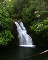 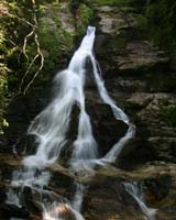 Click Here For Photos Of The Waterfalls Click Here For Photos Of The Waterfalls
|
| Map |
Coming Soon! |
| Directions: |
From Helen, go north on GA 75 11.3 miles. Turn a very sharp right on Indian Grave Gap Road (FS 283). This road is the first on the right after passing Unicoi Gap. Ford the stream and continue up the bumpy hill. At 1.4 miles from GA 75, the road reaches a level spot and curves to the right. The parking area and trailhead are on the left.
From Unicoi Gap, go north on GA 75 2 miles. Turn a very sharp right on Indian Grave Gap Road (FS 283). This road is the first on the right after passing Unicoi Gap. Ford the stream and continue up the bumpy hill. At 1.4 miles from GA 75, the road reaches a level spot and curves to the right. The parking area and trailhead are on the left.
From The Upper Chattahoochee River Campground, take a left out of the campground and proceed up the mountain until it dead ends into GA Hwy 75. Turn left and proceed to the top of Unicoi Gap. From Unicoi Gap go 2 miles north. Turn a very sharp right on Indian Grave Gap Road (FS 283). This road is the first on the right after passing Unicoi Gap. Ford the stream and continue up the bumpy hill. At 1.4 miles from GA 75, the road reaches a level spot and curves to the right. The parking area and trailhead are on the left.
|
| Reservations: |
Required - Contact Jeremy Landers by email or phone 770-861-8175
Or
Fill out the reservation info below |
| Post Trip Review: |
A Letter from the Grace Church Hike Group
To: Our friends back home.
We hope that this letter finds you all in good health and spirits.
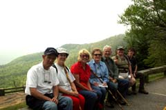
As you may know several of us departed Gainesville on September 15, 2006 and made our way northward to a place above Helen Georgia called Unicoi Gap where the Appalachian Trail crosses Ga Hwy 75. Here we entered the Mark Trail Wilderness area and traveled along the winding Chattahoochee River Road where we arrived at our camp for the next two nights on Horse Trough Mountain. Having arrived first Jeremy selected a wooded spot alongside the Upper Chattahoochee River not far below Horsetrough Falls and setup camp. Upon Arrival of Ron and Karyl in their RV and Helen and Stephanie who pitched their tent along side the river as well we enjoyed a steak and burger dinner and fellowship around the camp fire. We were all off to our tents or RV by 10pm and looking forward to the hike to High Shoals and Blue Hole falls on Saturday.
The next morning found us scurrying around the campsite cooking breakfast, packing lunches and readying backpacks for our days adventure. Having left the campsite a little later than intended we headed back up to Unicoi Gap a 20 min. ride from our campsite. At the Gap we met up with Marsha as planned and waited on one other. No luck on the arrival of the one other person so we loaded up again and headed to Indian Grave Gap Road, forded the Hiawassee River and headed up to the trail head at an elevation of 2880 feet. Descending along steep switchbacks, we made our way down the mountain and along High Shoals Creek through a primitive camp site and a tunnel like Mountain Laurel thicket. Upon arrival at the first side trail we encountered two rather confused hikers who seemed somewhat disoriented, telling us that there was only one waterfall. We told them that there were indeed two but they chose not to go back to see if we were correct or not. The first of the two falls is Blue Hole Falls accessible by a short side trail and is a great summer water hole. The second turn off to High Shoals Falls is farther down the main trail beyond the first turn off. You can't miss the box steps that switch back and descend again. If at this point you continue onward along the main trail as the two confused ladies we met did. You will ruin your sense of remoteness by plunging into the middle of a subdivision. Having seen both falls, made many a good photo, and a good rest we headed back up the trail towards the primitive campground to sit by High Shoals Creek to eat our lunch. Hiking out took a little longer due to the steepness of the trail but we all made it back to the truck and the promise of home made ice cream once we returned to our camp.
Upon arrival in camp Stephanie and Helen rolled up their tent, packed their truck and then we all headed over to the RV to try some of Karyl's "Peach Freeze". After our ice cream treat and having had a wonderful weekend in the mountains we all said our good byes as all but Jeremy were heading
back to Gainesville. The peace of the mountain, sitting next to your campfire with a good book and the river gurgling it’s way to the gulf is by far one of the best ways to spend a Saturday night.
A great time was had by all, and we all look forward to seeing you on the trail with us next time.
Peace+
Jeremy, Marsha, Ron, Karyl, Stephanie and Helen.
If the hike group sounds like fun to you visit www.LandersStudios.com/gechike to sign up for the hike group email list (If your email has [GEC-Hike] in the subject line you are already on the list) and for more information on our upcoming hikes. You may also contact Jeremy Landers at jlanders@gracechurchgainesville.org / 770-861-8175 cell |
|
|
 |
|
|
|
|
|
|
Camp on Friday and Saturday Nights
|
|
|
| Trip: |
Upper Chattahoochee River Campground |
| Date: |
September 15 & 16, 2006 (Stay one or both nights) |
| Trip Host: |
Jeremy Landers |
| Location: |
Union County, GA |
| Cost: |
$10.00 per day (rate as of March 2006) |
| Departs From: |
N/A, Meet at the Campground. |
| Departure Time: |
N/A |
| Meals: |
You are responsible for your own meals, supplies, cooking gear, tents, etc.
I'll provide charcoal for the grill.
This is bear country. Please practice safe food storage.
We will all gather together for meals and fellowship.
Trash cans are no longer supplied at this campground. |
| Transportation: |
Carpool |
| GPS Info: |
NA |
Requests,
Rules, Regulations, Requirements |
Please be considerate of others.
Campsites are on a first come first serve basis!
No Smoking
No Pets
No Radios, TVs
No more than 5 persons to a campsite
No more than 2 vehicles per camp unit.
|
| Notes: |
The elevation is 2,260 ft.
The campground is very picturesque and is located along Upper
Chattahoochee River in tall, mature mixed woods. Excellent
campground for relaxing, fishing, enjoying the scenery. Each of the 34 sites has a picnic table and fire ring/grill
This is bear country; practice safe food storage techniques.
RV INFORMATION
Hookups: None
Group RV Sites: Yes
No. RV Pull Throughs: 4
Waste Station: No
Largest Parking Apron Size: 10.5' X 60'
BATH AND SHOWER FACILITIES
Vaults: Yes
Flush Toilets: No
Hot Showers: No
OTHER FACILITIES
Playground: No
Public Phone: No
No. Water Spigots (non-site): 2
No. Threaded: 0
Wheelchair Friendly Toilets: Yes
WATER SPORTS - None
HIKING
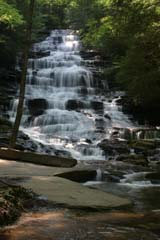
Horse Trough Falls - 0.3 miles
FISHING
Stocked Rainbow Trout |
| Links & Ref. |
|
| Photos |
 Horsetrough Falls At The Upper Chattahoochee River Campground Horsetrough Falls At The Upper Chattahoochee River Campground
 Upper Chattahoochee River Upper Chattahoochee River |
| Map |
http://www.georgiahikes.com/maps/bin/horse_trough_falls.gif
Campground map PDF |
| Directions: |
Version #1
From Helen Ga. Continue through Helen and Robertstown on Hwy. 75 to just before you crest the top of Unicoi Gap. Turn left onto Forest Service Road #44 (Mark Trail Wilderness Area) go approximately 5 miles to the campground. Turn right and cross bridge.
If bringing an RV this is the way to come now. New road improvements have made this route wider in spots. It is much shorter than version #2.
Version #2
From Helen Ga. Continue through Helen to Robertstown. Turn Left onto Alt. 75. Take the first road to the right Poplar Stump Road. You will see Cool River Tubing at the corner.
1.8 Pavement Ends
2.3 Bridge to right FS 179 (Stay Straight)
3.1 Check Station
4.4 FS 44A & Low Gap Campground
Turn Right and cross Bridge
9.7 Upper Chattahoochee River Campground
It's about a 45min ride from Robertstown on the FS Road.
|
| Post Trip Review: |
See Above for the hike review. |
|
|
|
Make A Reservation For This Trip
Bold Fields Are Required
|
|
|
|
|
|
Additional Info For All Hikes
Information provided by Marsha Conner
ICE INFO
(In Case Of Emergency)
We are now carrying ICE cards with us for safety. The hike planner will
be responsible for being sure these cards are on the trail. An index card
with critical contact and medical data on each hiker will be available in
case of emergencies. You are not required to participate in the
ICE program, but should an emergency arise, this data would go with
you for medical treatment and provide contact information for your relatives
and medical information at the ER that should be known. Many of us have
ICE phone numbers in our cell phones, but our cell phones may not work
in some wilderness areas.
WHAT TO CARRY
1. Daypack
2. Water/Fluid Supplies
3. Food/Snack Supplies
4. Cash and ID (ID should be on your person at all times)
5. Other Outdoor Supplies
1. Packs:
a. Plan and pack for medical emergencies including
blisters, bug bites, allergies, cuts, etc.
b. At least one snake bite kit (Sawyer style) should be
with the group (sold in most sporting goods depts).
c. Weather change needs such as poncho, emergency
blanket, cap, gloves, wind jacket, etc.
d. Cell phone (in case it might work) and other
items important to you for personal safety or comfort
2. Water/Fluid Supplies
a. Plan on carrying a cooler with ice to keep food and
fluids cold throughout the trip
b. Carry enough fluid with you for the designated trail hike
c. Do Not Drink Water From Streams - most mountain
water is no longer safe to drink as they may contain
protozoan imps and make you very sick
3. Food/Snack Supplies
a. Short hikes may only require a light snack
on the trail (1-2 miles) - plan accordingly
b. Longer hikes usually require a moderate
snack on the trail (3-4 miles) - plan accordingly
c. Remember that your appetite is enhanced by
being outdoors and doing physical activity
4. Cash and ID
a. Carry bills in different increments especially "ones"
for park entrance fees and incidentals - each
person is responsible for their own fees and should
share any group cost for parking and fuel
b. For your safety, have your ID with you on the trails
c. Do not leave valuables in your parked car which you
cannot afford to have stolen!
5. Other Outdoor Supplies
a. Camera and plenty of film
b. Binoculars
c. Sun hat
d. Knife and compass
e. Extra socks if prone to blisters
f. Bug spray
g. Sting relief especially if you are
allergic to insect stings
h. Hiking pole or sticks
i. Sweat towel and/or bandana
j. Large Pepper Spray (for animal attacks and personal protection)
UPON RETURNING HOME
1. Critical - Shower and check your body - CAREFULLY -
for ticks (if a tick has attached itself to your skin, do
not crush its body while removing it, but lift it away
from your skin and pull out by the legs - treat the area
properly and watch for any redness - if redness appears
seek medical attention promptly)
2. Clean and treat any wounded areas of your body -
use ice for first 24-48 hours on joint/muscle injuries
and heat as swelling subsides
3. Consider keeping a log of your hiking experiences and
write your story in a journal while memories are fresh
4. Develop pictures and share copies with your hikers
GENERAL GUIDELINES TO REMEMBER
1. Leave pets at home if hiking with a group
2. Keep groups on the trail to no more than 4-6 together
3. Walk single file in the middle of the trail
4. Step to the side of the trail as you go downhill
to allow hikers going uphill to have the right of way
5. Do not wade with your boots on unless necessary
Wet socks and shoes can create immediate blisters
6. Swift water can cause you to lose your footing in
6-12 inches of water so do not be fooled that you
can wade without danger across a stream
7. Snakebites are a critical concern to hikers
THINK before putting your hands and feet anywhere
that might be a place of hiding for a snake:
a. Step on the top of logs - not over them
b. Use your hiking pole to check on the backside
of logs and rocks before sitting down
c. Stay on the trail where visibility is better
8. Read the many different theories on protection
from bears and other wildlife - bears are most
aggressive when protecting their cubs and stay
near water and food sources frequently - bears
do not "growl" but will make a "grunting" noise
to let you know they see you when you may not
see them - stop, back away slowly, and move
back down the trail without hesitation - do not
mistake a "grunting" noise for random woods noise
on a trail as it may only be made one time to give
you one chance to back away. Carry a large
pepper spray.
9. Let members of your hiking group know your intentions
in case you decide to return to the parking lot or leave
for the day.
10. Remember that the GEC Open Hike each month will
have a mixed skill level and cooperation as a team is needed.
The monthly planner has volunteered to set up the hike
and there may be slight differences with each hike.
There is room for both the scenic hiker and the extreme
hiker with good communication and proper planning.
|
|
|
|
|
|
|
|
|
|
|
|

