|
Basic Info, More detail to follow at a later date.
|
| Data Updated: |
Friday, May 15, 2009 12:30:36 AM |
| Weather: |
Trip goes rain or shine!
Click here for Current Pickens, SC forcast |
| Trip: |
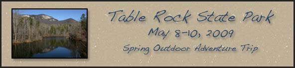
Table Rock State Park
Spring Outdoor Adventure Trip |
| Date: |
May 8-10, 2009
This is spending the night on Friday and Saturday Nights and departing on Sunday. You are welcome to go up early or stay later than the planned dates.
Please note this is a three day two night trip! |
| Trip Host: |
Marsha Conner & Jeremy Landers |
| Location: |
Table Rock State Park (Base Camp)
Caesar's Head State Park (Saturday Hike Location)
|
| Park Contact Info |
Table Rock State Park
158 E Ellison LN
Pickens, SC 29671
Phone: 864-878-9813
Fax: 864-878-9077
Wireless Internet available in the Visitors Center during operating hours. See the desk for a password. |
| Schedule: |
This schedule is a work in progress. Please check back later as we firm up the details.
Thursday
May 7 |
Early Birds check into their lodgings.
2pm Campsites
4pm Cabins |
Friday
May 8 |
Check In To Lodgings
2pm Campsites
4pm Cabins |
Saturday
May 9 |
Hike to Raven Cliff Falls Overlook. Caesar's Head State Park. |
Sunday
May 10 |
Check out of lodgings & campsites
10am Cabins
12pm Campsites
Morning Prayer Service |
|
| Reservations: |
If you are interested in this trip YOU need to make lodging or camping reservations as soon as possible. The church will NOT be handling any reservations. Once you have made your reservations please contact Jeremy Landers or Marsha Conner so we can add you to our list.
Reservations should be made through www.southcarolinaparks.com
either by phone or the online reservation system.
|
| Accommodations: |
Table Rock State Park
(Base Camp) |
Table Rock State Park
Built in the 1930s by the Civilian Conservation Corps (CCC), as a part of President Franklin D. Roosevelt's "New Deal" program, it has remained one of South Carolina's most popular state parks. Many of its structures are now on the National Register of Historic Places.
The park features 3083 acres, two lakes, a campground, 14 cabins, 2 fishing piers, beach with diving boards, more than 12 miles of hiking trails, pedal boat, kayak, canoe & john boat rentals. It also serves as trailhead for the 80 mile foothills trail.
Camping
Our base camp and central gathering place for the duration of the trip will be at Jeremy & Marsha's campsites.
Campers have the choice of a 69 site camping area near the park entrance, or a 25 site camping area located near White Oaks picnic area. We will be in the 69 site camp area as it is on the same side of the park as the cabins. Each site has individual water and electrical hookups and picnic table. Campgrounds are convenient to restrooms with hot showers. Some sites accommodate RV's up to 40 feet.
There is also a primitive walk in camp area with central water located near Lake Oolenoy.
Camping reservations must be made for a minimum of two nights.
The park has an RV dump station and laundry facilities as well as a store with basic camp supplies (store open weekends only spring & fall).
Cabins
Cabins are completely furnished, heated, air-conditioned, and supplied with bath and bed linens, basic cooking and eating utensils, automatic coffee maker, a microwave, and include a screened porch and fireplace.
Cabin #15 is user friendly for the physically impaired.
Pets are not permitted in the cabins or cabin area.
One, two and three-bedroom cabins are available.
|
| Other |
These are other accommodations near Table Rock State Park from Google Maps. We do not know anything about these locations. Please do your own research prior to making reservations.
www.theinnattablerock.com
www.laurelmountaininn.com
www.tablerockresort.com |
|
| Things to do At Table Rock: |
| Fishing Information: |
Fish in Pinnacle Lake (36 acres) and Lake Oolenoy (67 acres) for bass, bream and catfish.
A South Carolina fishing license is required.
A fishing pier accessible to the physically impaired is located on Lake Oolenoy.
The park visitors center has loaner, rod, reel & tackel. |
| Boating: |
A boat ramp provides private boat access to 67 acre Lake Oolenoy. (Electric trolling motors only)
Jeremy will have two sit on top kayaks for our use in Lake Oolenoy.
Rental canoes, kayaks and pedal boats are available at Lake Pinnacle during the summer months contingent upon the availability of lifeguards.
The park tells us that boats should be available on the weeknd we are there unless there are budget cuts.
Non-motorized fishing boat rentals are available at the 36-acre Pinnacle Lake for $15 from 11:00 a.m. to 5:00 p.m.
Motorized fishing boat rentals are available at the 36-acre Pinnacle Lake for $25 for 11:00 a.m. to 5:00 p.m.
All rentals are subject to availability and favorable weather conditions.
|
| Trails |
Table Rock offers more than 12 miles of trail. Some of which carry hikers past streams and waterfalls to the top of Table Rock and Pinnacle mountains. Table Rock is an access point to the 80 mile foothills trail as well.
Mileage shown below is one way. Most trails are rated as moderately strenuous or strenuous. You must register with the park before hiking.
Carrick Creek (1.9 miles)
Mill Creek Pass (0.7 mile)
Pinnacle Mountain (4.1 miles)
Ridge (1.9 miles)
Table Rock NRT (3.6 miles) |
|
| Difficulty: |
Moderate (Saturday Hike To Raven Cliff Falls) |
| Length: |
4.4 Miles Round Trip (Saturday Hike To Raven Cliff Falls) |
| Blaze: |
Red (Saturday Hike To Raven Cliff Falls)
|
| Departs From: |
No official carpool.
If carpooling please make arrangements with the people you are riding with. |
| Departure Time: |
No official carpool.
If carpooling please make arrangements with the people you are riding with. |
| Meals: |
Please bring your own food or make arrangements with other people in your cabin or campsite to share meals. There are not many eating establishments in the area.
Jeremy will usually have a campfire in the evenings and you are welcome to bring your meat for the grill. (Park rules limit 6 people to a site at a time)
The only place to eat out near Table Rock.
www.auntsues.com |
| Transportation: |
POV's with carpooling, or drive on own. If you need transportation you can post an email to the hike group email list.
No official carpool for this trip.
(Always be prepared to drive your own vehicle if necessary. If you carpool, fuel costs should be shared.)
|
| GPS Info: |
|
| USGS Quad: |
Table Rock |
| Ranger District: |
|
Area
Trail Descriptions: |
See above for Table Rock Trails
Raven Cliff Falls (Saturday Hike Group Trip)
This 400-foot waterfall always provides a great picture taking opportunity. From either the observation platform below, or from a suspension bridge above; both equally rewarding and worth the moderately difficult hike.
The trailhead is across the highway from the parking lot and there is a register that you must sign before setting out on the trail. After signing, follow the Raven Cliff Falls Trail (Red Blazes, #11) as it descends via an old gravel road into the forest. The trail then levels off and follows the ridgeline with fantastic views over the Blue Ridge Escarpment. After a mile or so, the trail descends down three flights of wooden steps amid rhododendron and mountain laurel. It was just past this section that we spotted a deer and her fawn walking on the hillside above us—yet another nice surprise.
|
| Notes: |
More information to come at a later date on hiking times, trails etc.
First let us remind you that this trip is not just for hikers. There are lots of things to do at Table Rock & in the area for those of you who don't hike. Whether it's bird watching, fishing, reading or driving around consider joining us on this trip!
Over the next several months, we will work on an exact schedule, but the important issue at this time is for each hiker to consider if they want to participate in this event and to make their reservations for accommodations. Please understand that there are NOT a lot of places to stay other than the park, so start studying the locations, think about your options, and consider making your plans for accommodations. After a day trip of scouting the area, Jeremy and Marsha can now share all the info with you that we obtained, but we encourage each participant to look at the web sites and talk to us about the options. Please BOOK SOMETHING NOW, even if your plans change later on.
At this time, Jeremy and Marsha will be camping and the base camp location will be Table Rock State Park Loop A Sites 44 (Jeremy) and 46 (Marsha). If you plan to CAMP, you need to talk with Jeremy or Marsha so you can make reservations close together. I do not suggest taking a chance on getting a camping site upon arrival. Making reservations for camping at this location is highly recommended.
There are numerous websites to study and gather info, so please take some time to look and learn. Even if you have to change things later in the year, we recommend you make some plans now as the accommodations are not plentiful and could book up early.
As we did last year, we will schedule the hike at Caesars Head State Park for Saturday (with possibly some other activities in the area) so that those who travel on Friday will be there for the primary hike. Those who wish to go over on Thursday may select their own schedule for Friday.
NOTE the dates for this event. This hiking event will be the second weekend of May! You may go up as early as you wish and stay as long as you like but the primary hike will be on Saturday, May 9, 2009. Please let Marsha know your plans as soon as possible so we can know how many people are going, where they are staying, and the dates they will be there.
Cellular phone service is sporadic in the park so don’t count on that service to be reliable.
Wireless internet is available in the visitors center during business hours. Please inquire at the desk for the password. |
| Date Conflict Notice: |
An Evensong service was scheduled for Sunday May 10th at 5pm at Grace after the dates for this trip were set on the church calendar and reservations made. There was not another spring weekend that would work for rescheduling our trip. Please be aware of this conflict and make your plans accordingly. We are sorry for this inconvenience especially to our hikers from the choir who will not be able to join us. |
| Links & Ref. |
www.sctrails.net
www.southcarolinaparks.com
Table Rock Webcam
|
| Books |
South Carolina Nature Viewing Guide
The Waterfalls of South Carolina
Pickens County (SC) (Images of America)
Reflections of South Carolina
Hiking Trails of South Carolina
A Guide to the Wildflowers of South Carolina
|
| Photos |
Hike Group Photo Gallery
Table Rock SP Photo Gallery |
| Map |
Table Rock Map (PDF Download)
Caesars Head Map (PDF Download)
|
| Directions: |
View Driving Directions Map from Google Maps
Driving directions to Table Rock State Park Visitors Center
158 E Ellison Ln, Pickens, SC 29671
101 mi – about 2 hours 40 mins
Starting Address
Grace Episcopal Church
422 Brenau Ave
Gainesville, GA 30501
| 1. |
Head northeast on Brenau Ave toward Blvd
335 ft |
| 2. |
Turn right at Blvd
0.1 mi |
| 3. |
Turn left at Spring St SE
0.1 mi |
| 4. |
Turn right at Prior St SE
0.2 mi |
| 5. |
Turn left at GA-13/Jesse Jewell Pkwy SE
2.2 mi |
| 6. |
Turn left to merge onto GA-365/US-23 N
28.7 mi |
| 7. |
Slight right at GA-365/US-123
Continue to follow GA-365
6.3 mi |
| 8. |
Turn left at W Currahee/Dicks Hill Pkwy/GA-123/GA-184/GA-365
Continue to follow GA-365
Entering South Carolina
10.5 mi |
| 9. |
Continue on US-123
14.6 mi |
| 10. |
Exit on the left onto SC-11
38.5 mi |
| 11. |
Turn right at E Ellison Ln
0.1 mi |
Ending Address
Table Rock State Park
158 E Ellison Ln
Pickens, SC 29671
|
| Reservations: |
Please Let Jeremy Landers or Marsha Conner know once you have made reservations with the park.
Reservations for camping or cabins should be made with the South Carolina State Park System.
*Special Notice Regarding Hikers Under 18 Years of Age!
|
| Post Trip Review: |
The spring 2009 OAT is history now and everyone is back home safely. We missed lots of our regular hikers, but we know there were some schedule conflicts. We certainly hope we can resolve that situation for next year.
Jeremy and Marsha checked in at Table Rock on Tuesday the 5th. The trip up was uneventful and only took about 2 hours. Jeremy and Marsha were camping just across the street from each other in the main campground area. After our initial setup was over, we rode down to one of the lakes to spend some time kayaking before sunset.
On Wednesday, Marsha spent the afternoon exploring nearby communities in between rain showers and Jeremy spent the day reading a good book. On Thursday, Marsha spent most of the day exploring sections of DuPont State Forest nearby in North Carolina. Jeremy spent the day enjoying more time at Table Rock. Thursday evening, Marty and Frances arrived and joined us for the campfire.
We had some rain showers off and on, day and night, but Friday morning we had a real thunderstorm for about thirty long minutes. All of our equipement held up just fine and there was really no damage, just a lot of water added to the streams. Friday afternoon, Jeremy and Marsha were able to spend some more time kayaking.
The weather forecast for Saturday called for more thunderstorms so we modified the hike schedule and location. The decision was made to hike to some of the waterfalls in DuPont State Forest rather than Raven Cliff Falls. Sure enough, we still got caught in a rain shower about .2 mile from the parking lot, but, well, it was just some rain and we joined some other folks under a bridge until it was over. We did get to enjoy some really beautiful water falls in the forest that were running very, very strong.
Saturday evening, we all grilled out together and enjoyed another campfire. Our culinary skills are also improving for cooking outdoors and Jeremy also treated us to some great food from his cast iron, dutch oven system.
Sunday was clean up, pack up, and travel home day. At least we did not have rain showers while we were packing up, so everything was dry. After packing camp & cabin Marsha, Frances & Marty all headed home. Jeremy spent the day at Table Rock & hiked the Carrick Creek Trail.
Check out the Photo Gallery for some pictures
Jeremy and I are already sharing thoughts on the OAT for 2010. We will do some scouting in the late summer and make a selection in early fall this year. Table Rock State Park and the surrounding wilderness areas were great locations and a good trip this year. I am sure whatever we select for 2010 will be just as good! |