|
| Weather: |
Trip goes rain or shine!
Click here for the the 10 day Robbinsville, NC forcast |
| Trip: |
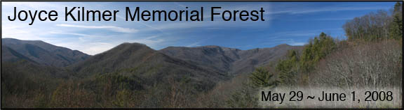
Joyce Kilmer Memorial Forest, Nantahala National Forest
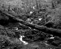
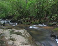
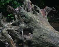
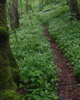
Step back in time on a hike through Joyce Kilmer Memorial Forest's towering trees some as old as 400 years. Enormous yellow poplar over 20 feet in circmference standing over 100 feet tall grace the forest. The forest floor is carpeted with ferns, moss, wildflowers and giant fallen trees. |
| Date: |
May 30 - June 1, 2008
This is spending the night on Friday and Saturday Nights and departing on Sunday. You are welcome to go up early on Thursday or stay later than the planned dates.
Please note this is a three day two night trip! |
| Trip Host: |
Marsha Conner |
| Location: |
Joyce Kilmer Memorial Forest Trail.
Other hike locations to be determined witin the next few mothns. |
| Schedule: |
This schedule is a work in progress. Please check back later as we firm up the details.
Thursday
May 29 |
Early Birds check into thier lodgings.
|
Friday
May 30 |
Tour Fontana Dam, & explore surounding area
Check In To Lodgings |
Saturday
May 31 |
Hike Joyce Kilmer Memorial Trail
Looking in to a pontoon boat rental on Lake Santeetlah |
Sunday
June 1 |
Check out of lodgings |
|
| Reservations: |
If you are interested in this trip YOU need to make reservations as soon as possible. The church will NOT be handling any reservations. Once you have made your reservations please contact Jeremy Landers or Marsha Conner so we can add you to our list.
|
| Accomadations: |
Choeah Point Campgound
(Base Camp) |
Choeah Point Campground
www.recreation.gov
Cheoah Point Campground Reservation Page
Cheoah Point Cabin #1 Reservation Page
Cheoah Point Cabin #2 Reservation Page
Choeah Point Campground site 18 will be our base camp and central gathering place for the duration of the trip. Choeah Point is located 6.8 miles North of Robbinsville, NC, (take U.S. Rt. 129 north 6.8 miles to Cheoah Point Recreation Area sign. Turn left at sign and go 0.1 miles to Cheoah Point campground sign. Turn left at sign and go 0.7 miles to campground entrance.)
The elevation is 1,760 ft.
The campground is situated in mature hardwoods on a peninsula overlooking Lake Santeetlah. The lake can be seen through the dense woods some 150 feet away. The campground is close to the beach and boat ramp and has numerous terraced campsites without power and back in 40ft campsites with 15amp electric. There is a central water supply but no indvidual site water supplies. The campground has a bath house with flush toilets and hot showers. The campground does not have a dump station.
Campers have the choice of reserved sites with power $20.00 (only 4 sites with power are left) or non reserved walk in sites without power.$15
***Checkout time is 11am. You may want to consider adding an extra night so you don't have to vacate your campsite until later in the day Sunday. Jeremy has done this.
The campground also includes two primitive cabins which are available for rent on Recreation.gov.
Base Camp Reservations Are: May 29 - June 2. Actual departure Sunday June 1st.
|
| Tapoco Lodge |
www.tapocolodge.com
Beautifully situated on 120 acres among the lush mountains of the Nantahala National Forest and the cascading whitewater rafting of the Cheoah River. Located 15 miles north of Robbinsville, North Carolina.
Built in 1930 by the Aluminum Company of America as part of hydroelectric efforts in Graham and Swain counties of North Carolina $75 - $109
|
Phillips
Motel |
www.phillipsmotelonline.com
Located near the Great Smoky Mountains in Robbinsville,
the Phillips Motel offers motel, efficiency rooms, and cottages
at a reasonable price.
We've created a comfortable, relaxing atmosphere
conveniently located on Main Street. $35-$125
|
| San-Ran Motel |
www.mountainhomepage.com/sanran
The San-Ran Motel, a family owned business since 1958, is located on US 129 in Robbinsville, North Carolina in the heart of Graham County. We offer newly renovated, quality, clean rooms at reasonable rates. Secure off-street private parking with room for trailers in back and covered parking for motorcycles. Several restaurants with-in walking distance. $45
|
| Microtel |
www.microtelrobbinsville.com
• 50 guest rooms
• Singles, doubles, suites, Jacuzzi suites available
• Suites include microwave, refrigerator, coffeemaker, 1 queen bed, one queen sleeper sofa
• Special rooms and suites for physically challenged
• Non-smoking rooms and suites available
• Adjoining rooms for expanded families
• Free local calls (dataport phones)
• Remote control satellite color TV with HBO, ESPN, CNN, and TWC
• Complementary continental breakfast
• Meeting room for groups and clubs
• Selected pet rooms
• Interior corridors with electronic locks and elevator
•
$59.95
|
| Blue Boar Inn |
www.blueboarinn.com/index.html
Fine Lodging and Dining |
|
| Difficulty: |
Joyce Kilmer Trail: Easy
Other Trails: Easy-Moderate, Moderate, Moderate to Strenuous depending on selected trails. |
| Length: |
Jocye Kilmer Trail 2 Miles
Other trails in the area vary in length. |
| Blaze: |
Blaze Varies |
| Departs From: |
No official carpool.
If carpooling please make arrangements with the people you are riding with. |
| Departure Time: |
No official carpool.
If carpooling please make arrangements with the people you are riding with. |
| Meals: |
Please bring your own food or make arrangements with other people in your cabin or campsite to share meals. There are several eating establishments in Robbinsville as well. |
| Transportation: |
POV's with carpooling, or drive on own. If you need transportation you can post an email to the hike group email list.
No official carpool for this trip.
(Always be prepared to drive your own vehicle if necessary. If you carpool, fuel costs should be shared.)
|
| GPS Info: |
|
| USGS Quad: |
|
| Ranger District: |
Cheoah |
Area
Trail Descriptions: |
Joyce Kilmer Memorial Trail (Official Group Hike, Saturday Morning)
Other Area Trails
Slickrock Creek Trail
NakedGround Trail
Hangover Lead South Trail
Cheoah Trail
Massey Branch Fitness Trail
Snowbird Loop Nature Trail
Listing of Area Trails |
| Notes: |
More information to come at a later date on hiking times, trails etc.
(This Section From Marsha's Email To The Group)
GEC HIKE GROUP - 2008 OVERNIGHT TRIP -
MAY 30 – June 1
GRAHAM COUNTY/ROBBINSVILLE, NC – JOYCE KILMER FOREST
LOCATION & INFORMATION:
The location for the 2008 overnight hiking event will be Graham County, NC. The county seat is Robbinsville, NC. This is about 100 miles North of Gainesville and there are several routes to select from for traveling, but all include lots of hills and curves. This county is located in the very southwest corner of NC and borders on TN. Allow 3 hrs. travel time with breaks.
Graham County is a very rural area and 96% of the county is forested land, and of that land 60% is Federal and National Forest property. The county elevation ranges from 1,100' on the northern border to 5,530' on the southwest corner. There are over 225 miles of National Forest hiking trails in Graham County alone. Tourism is the primary income for the county and the two main groups which travel to Graham County are outdoor adventuress and motorcyclists.
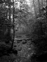
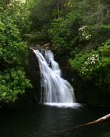
Besides the forests, there is water, water everywhere. A recent agreement between the Forest Service, Alcoa Comp., and Graham County has provided for water releases on the Cheoah River. It goes from a small stream to roaring river levels. This is a 9 mile stretch of water which runs from Santeetlah Dam to Cheoah Dam almost parallel to Hwy 129. This river has become a haven for kayakers and is now serviced for guided raft rides by most of the major river runner companies in season (NOC is one you may be familiar with by name).
Just above the Cheoah Dam, is an 11 mile section of highway known as the "Tail of the Dragon" as it has 318 curves in those 11 miles and motorcycle riders travel far and near to ride this roadway (and yes, some bikes, and a few bikers, have not survived the ride). You can see the "memory tree" which is decorated with pieces of bikes hanging from the limbs (no body parts though).
Between Robbinsville and the Cheoah River, is the large, finger shaped Santeetlah Lake. On the West side of this lake is our primary target - The Joyce Kilmer Memorial Forest. This forest was named in memory of Joyce Kilmer who was a WWI soldier and wrote the poem, "Trees". This forest is located within the Slickrock Wilderness Area which is located within the Nantahala National Forest. Within JKMF you will find some of the largest remaining trees in the southeast as this section has never been harvested for timber. The memorial trails in the JKMF create a figure 8 with a lower loop and an upper loop. Although not long in length, the 2 miles of trails will allow us an interesting journey deep into a beautiful forest with several altitude changes and wonderful photo opportunities.
The Fontana Dam/Resort is to the northeast of Robbinsville and is the highest dam in the East. For those who arrive on Thursday, touring this area is an option.
Over the next 3 months, we will work on an exact schedule, but the important issue at this time is for each hiker to consider if they want to participate in this event and to make their reservations for accommodations. Please understand that there are NOT a lot of places to stay either in Robbinsville nor in the forested area, so start studying the locations, think about your options, and consider making your plans for accommodations. After a day trip of scouting the area, Jeremy and Marsha can now share all the info with you that we obtained, but we encourage each participant to look at the web sites and talk to us about the options. Please BOOK SOMETHING NOW, even if your plans change later on. We will be a little more spread out this year just due to the logistics of the area and accommodations available.
At this time, Jeremy and the Welch's will be camping and the base camp location will be Cheoah Point which is a campground on the Santeetlah Lake just outside of Robbinsville (to be honest, it is the only campground with water and power in the area). If you plan to CAMP, you need to talk with Jeremy so you can make reservations close together. I do not suggest taking a chance on getting a camping site upon arrival. Making reservations for camping at this location is highly recommended. Jeremy will be at site #18.
If you want to stay in Robbinsville, there are 3 locations we found to recommend. The only franchise motel is the Microtel. There are 2 "home owned" motels we found to be charming and very appealing. The San-Ran motel reminds you of the motor lodges of the '50's and is a small single row of units. The Phillips motel includes about 16 rooms, some cottages, and even some 3 bedroom housing units. There are some franchise eateries in Robbinsville, and 2 local restaurants near the motels. At this time, I have no price info to share with you.
There is one very unique lodge near the Cheoah Dam which is also a good prospect, but they do not open until April 1. You can make reservations prior to that by E-mail or phone. It is Tapoco Lodge and was built in 1930 by the Alcoa Company as a private retreat. The prices for this lodge are much less than the 3-4 other lodges in the county which are all new and off road. This lodge has its own restaurant on site and the Cheoah River runs in front of it. Note that the cabins have between 2-4 rooms in each cabin.
There are numerous websites to study and gather info, so please take some time to look and learn. Even if you have to change things later in the year, we recommend you make some plans now as the accommodations are not plentiful and could book up early. Many large groups use Tapoco, Robbinsville, and Fontana for annual gatherings seasonally.
As we did last year, we will schedule the hike into JKMF for Saturday (with possibly some other activities in the area) so that those who travel on Friday will be there for the primary hike. Those who wish to go over on Thursday may select their own schedule for Friday.
Just for interest - The Cheoah Dam was featured in "The Fugitive" when Harrison Ford jumps from a spillway while being chased. The movie "Nell" was filmed throughout Graham County starring Jodi Foster as well as the movie “In Dreams” with Annette Benning. The country music singer Ronnie Millsap is from Graham County. Almost 29 miles of the AT pass through Graham County. The town of Robbinsville was formerly Fort Montgomery and was the holding area for the Cherokee Indians as they were forced to leave the Southeast on the Trail of Tears.
Please contact Jeremy or Marsha with any questions. At this time, Jeremy will be camping at Cheoah Point and Marsha is trying to get a room at Tapoco Lodge, probably in one the cabins. Santeetlah cabin has 4 rooms in it and if enough people select the lodge, we could possible use all the rooms in that cabin. Go to the website for Tapoco Lodge to see the layout. I do not have all the details from the lodge personnel yet for information and reservations.
NOTE the dates for this event. This hiking event will be the last weekend of May! You may go up as early as you wish and stay as long as you like but the primary hike will be on Saturday, May 31, 2008. Please let Marsha know your plans as soon as possible so we can know how many people are going, where they are staying, and the dates they will be there.
Cellular phone service is sporadic outside of Robbinsville and in the forest so don’t count on that service to be reliable. |
| Links & Ref. |
www.grahamcountytravel.com
www.phillipsmotelonline.com
www.microtelrobbinsville.com
www.mountainhomepage.com/sanran
www.tapocolodge.com
www.recreation.gov (for campsites)
www.cs.unca.edu/nfsnc (for Cheoah Ranger District)
www.tailofthedragon.com
www.cherohala.com
www.nantahalawilderness.com
www.ncnatural.com/NCUSFS/Nantahala
www.junaluska.com
www.cherokeehistory.com
www.noc.com (Nantahala Outdoor Center)
www.santeetlahmarina.com (boat & cabin rentals)
www.theblueridgehighlander.com/graham_county_north_carolina
http://graham.main.nc.us/~rlofty/rentals.html (boat rentals, fishing & hunting guide services, hiker shuttle service)
www.deytoncamp.com (boat rental)
www.wncoutdoors.info |
| Books |
Hiking Trails of Joyce Kilmer-Slickrock and Citico Creek Wilderness by Tim Holman
|
| Photos |
Jeremy's Photo Gallery
Cheoah Point Campground
Santeetlah Lake |
| Map |
|
| Directions: |
|
| Reservations: |
Please Let Jeremy Landers know once you have made reservations! (770-861-8175 or email )
*Special Notice Regarding Hikers Under 18 Years of Age!
|
| Post Trip Review: |
The GEC Hiking Group enjoyed their annual
Outdoor Adventure Trip (OATs) recently by
visiting the Joyce Kilmer Memorial Forest just
outside of Robbinsville, NC. Eight hikers spent
3-4 days having a wonderful time sight seeing,
hiking, kayaking, swimming, cooking out, and
completed the weekend with a Sunday devotional
service outdoors beside the Cheoah River at the
Tapoco Lodge.
The weather was warm during the day and cool
at night with some overnight rain showers. Those
camping at Cheoah Point campground shared their
picnic area with everyone and the evening cookouts
turned into a real buffet. The Saturday night campfire
gave everyone time to share funny stories and talk
about the hiking experiences.
The hike into the Joyce Kilmer Memorial Forest was
memorable indeed. The huge popular trees on the back
side of the forest gave the group a chance to hold
hands around one of the largest trees. Everyone agreed
it was a truly special forest and moved by its history.
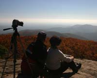
Taking lots of photos was the order of the day and
it was perfect weather to hike and take pictures.
Here are some questions you can ask our hikers:
Ask Marty Welch how much rain can pour into a
parked vehicle? Ask Frances Welch how you talk
to a snake? Ask Jeremy just how big you can smile
when you kayak a mountain lake? Ask Jeff Jones
how you program a GPS for nothing but curves?
Ask Polly Jones how cold the lake water was for
swimming? Ask Karyl Evans how to sleep while
riding the mountain curves? Ask Ron Evans what
makes a really crisp salad? Ask Marsha what 318
curves in 11 miles feels like? Yes, we had a good time!
The GEC Hike Group is open to our Parish members,
their family members, and friends upon the approval
of the event planners.
The next day hike is June 14th and will be a section
of the AT. Jeremy Landers is the event planner for
this hike and information may be found on the website: www.LandersStudios.com/gechike
|
|
|