Double Culvert Branch Black & White (Click To Order Print) © Landers Photographic Arts / Jeremy R. Landers © Landers Photographic Arts / Jeremy R. Landers © Landers Photographic Arts / Jeremy R. Landers Tree Trunk At Helton Creek Falls (Click To Oder Print) © Landers Photographic Arts / Jeremy R. Landers
Double Culvert Branc Trail (Click To Oder Print) © Landers Photographic Arts / Jeremy R. Landers
Hike Info Page
DO  NOT  CONTACT  THE  CHURCH   OFFICE 
TO  SIGN  UP  FOR  HIKES  NOR  FOR  INFORMATION

CONTACT  THE  HIKE  PLANNER  DIRECTLY
Trip: Panther Creek Falls
Date: Saturday, June 9th, 2007
Trip Host: Marty & Frances Welch
Location: Panther Creek Falls,
Off Hwy 441
Clarkesville, GA
Cost: Carry cash for fuel sharing, parking & dinner.
Difficulty: Moderate, does require a little climbing. Nothing major.
Length: 7.2 Miles Round Trip

It's 3.5 miles to the falls, however if you feel 7 miles is too much there are lots of places to stop and sit along the creek until we return.
Blaze: Blue
Departs From: 8:00 AM Quillian's Corner Chevron
Departure Time:
Meals: Bring A Trail Lunch, water and snacks.

Dinner Afterwards
Transportation: POV's with carpooling, or drive on own. If you need transportation you can post an email to the hike group email list.

(Always be prepared to drive your own vehicle if necessary. If you carpool, fuel costs should be shared.)

GPS Info:
USGS Quad: Tallulah Falls
Ranger District: Chattooga
Schedule: The projected  timeline with distances and events: Due to different paces, times for hike sections will differ. If you wish to carpool, let Jeremy or Marsha know or plan on meeting at one of the "meet up" locations shown.  Check with your driver to know their plans for the day.

8:00 AM Quillian's Corner carpool depart
9:00 AM Panther Creek Falls Parking Lot
9:15 AM Prepare to hike, safety briefing, introductions
9:30 AM Hike to Panther Creek Falls 3.5 miles
12:15 PM Lunch at Waterfall
1:00 PM Return hike to Parking Area
3:00 PM Arrive at Parking Area
3:30 PM Early Dinner in Area
6 PM Return to Quillians Corner for fueling of carpool vehicles and to pick up cars.

PLEASE REMEMBER:  Time lines are provided as projections and you may move in and out of the schedule as needed, but please let the hike planner known your intentions.  Things may move faster or slower than our projections due to many variables.  This hike will go rain or shine and will only be canceled for weather conditions which would be a safety hazard to the participants.  The bugs will be out by this date, so carry plenty of spray.

Schedule Subject to change. Allow time for the trip to take longer.

Trail Description: 
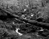
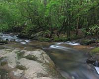
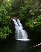
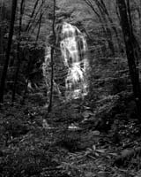
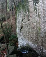
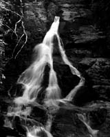
Panther Creek Falls trail makes an excellent 7.2-mile day hike.(Note that you don't have to do all 7 miles. When you have gone as far as you want, just find a shady spot to sit and rest) The trail follows a beautiful tumbling, cascading stream through a steep-sided valley with rocky cliffs to Panther Creek Falls. The trail leads down to the pool for a grand view of the falling water and the large pool catching it.

The parking area for the trail is about 15 minutes north of the Clarkesville square past Hollywood.

Most of the trail is flat - little to no uphill - some rough spots for footing (cables to hold on to in those spots)!! It will be a long day but most enjoyabe.... I would suggest bringing a good lunch and lots of water....

Frances
Notes:
Walk at your own pace!  Try to walk with someone when possible and try to stay in sight or sound of the main group which means the lead hikers may need to slow or stop to let the rear hikers catch up. This is a good reason to carry a whistle on you at all times. Lead hikers should stop at all trail intersections to let everyone gather before moving forward.

If you need a potty break while on the trail, just let someone know you are leaving the trail for a few moments and have that person wait nearby until you return. If you should feel ill or become weak while hiking, let Jeremy or Marsha know immediately. Do not push yourself forward on the trail under adverse conditions. One of us will work with you to maintain your safety. If you have any medical concerns that need to be known, be certain a hiking partner or Jeremy/Marsha know about any issues that could require immediate attention.

Carpoolers should share the cost of fuel when returning to their base location.

If you have any questions regarding the logistics for this hike, please contact Jeremy Landers. If you are signing up to hike or have transportation issues, contact Jeremy Landers.  More info on our hiking plans can be found at:  www.LandersStudions.com/gechike

PLEASE - DO NOT CONTACT THE CHURCH OFFICE REGARDING THE HIKES. THE CHURCH OFFICE DOES NOT HANDLE OUR PLANS NOR ROSTER FOR THIS ACTIVITY. CONTACT JEREMY OR MARSHA DIRECTLY.


HIKE  AT  YOUR  OWN  PACE - BUT  HIKE  WITH  A  PARTNER  OR IN  SIGHT  OR  SOUND  OF  YOUR  GROUP  FOR  SAFETY.
Links & Ref.
Photos
Map Map From www.georgiahikes.com
Directions: From Gainesville ( At Exit 24)
Take Hwy. 365 North (Note that this road will become hwy 441 once you get to the Toccoa / Lavonia Exit. You should stay on the 4 lane Hwy 441) approximatly 32.5 miles to traffic light intersection with Hwy 17, 385 and historic 441.

Turn Left and go approximatly 500 feet. You should have a gas station on both sides of this road.

Turn right at stop sign.

Road will fork in approximatly 3.4 miles. Stay to the right.

Go approximatly 0.5 mile. Trailhead parking should be in this area.


From Atlanta
Take Interstate 85 North

Turn Left Onto Interstate 985 North towards Gainesville

Interstate 985 becomes Hwy 365 at Exit 24 in Gainesville.

Follow directions above
Reservations: Yes, Make Reservation with Jeremy /
770-861-8175 or Click Here To Email
Deadline to Sign Up: Wednesday June 6, 2007

*Special Notice Regarding Hikers Under 18 Years of Age!

Post Trip Review:
Upper Chattahoochee River (Click To Oder Print) © Landers Photographic Arts / Jeremy R. Landers
Blue Hole Falls (Click To Order Print) © Landers Photographic Arts / Jeremy R. Landers
Fire Pink (Silene Virginica) Click To Oder A Print © Landers Photographic Arts / Jeremy R. Landers

© Landers Photographic Arts / Jeremy R. Landers
Landers Photographic Arts

Special Offer

Special Offer From Landers Photographic Arts (Click Here) © Landers Photographic Arts / Jeremy R. Landers

Horse Trough Falls (Click To Oder Print) © Landers Photographic Arts / Jeremy R. Landers
Raven Cliffs (Click To Oder Print) © Landers Photographic Arts / Jeremy R. Landers
High Shoals Falls (Click To Oder Print) © Landers Photographic Arts / Jeremy R. Landers

*Special Notice Regarding Hikers Under 18 Years of Age!


Please take a moment to read the Participation Guidlines prior to hiking with the Grace Church Hike Group.

Additional Info For All Hikes
Information provided by Marsha Conner

ICE  INFO
(In Case Of Emergency)

We are now carrying ICE forms with us for safety. The hike planner will
be responsible for being sure these cards are on the trail.  A form in a
sealed yellow envelope with critical contact and medical data on each
hiker will be available in case of emergencies.  You are required to fill
out the emergency contact information however the medical information
is optional, should an emergency arise, this data would go with you for
medical treatment and provide contact information for your relatives
and medical information at the ER that should be known.  Many of us have
ICE phone numbers in our cell phones, but our cell phones may not work
in some wilderness areas.

WHAT  TO  CARRY
You should be self-sufficient on the trail. Do not plan to borrow items you
do not have from people hiking with you. They may not have what you need
or they may need it for themselves. Carefully look over the trail description and
map before going, ask questions, and make sure that you are physically able to
handle the terrain, the temperatures, the possible wetness, and the other
interesting things that might happen to us while on the trail! As always we
set our hiking pace to accomadate everyone. So don't think you'll be too slow.
Jeremy & Marsha are always willing to help you to be trail ready.

1.  Daypack
2.  Water/Fluid Supplies
3.  Food/Snack Supplies
4.  Cash and Photo ID (ID should be on your person at all times)
5.  Other Outdoor Supplies
6. 4 AA Batteries to use in our walkie talkies.

1.  Packs:
a.  Plan and pack for medical emergencies including
     blisters, bug bites, allergies, cuts, etc.
b.  At least one snake bite kit (Sawyer style) should be
     with the group (sold in most sporting goods depts).
c.  Weather change needs such as poncho, emergency
     blanket, cap, gloves, wind jacket, etc.
d.  Cell phone (in case it might work) and other
     items important to you for personal safety or comfort

2.  Water/Fluid Supplies
a.  Plan on carrying a cooler in your vehicle with ice to keep
food and fluids cold throughout the trip
b.  Carry enough fluid with you for the designated trail hike
c.  Do  Not  Drink  Water  From  Streams - most mountain
    water is no longer safe to drink as they may contain
    protozoan imps and make you very sick

3.  Food/Snack Supplies
a.  Short hikes may only require a light snack
     on the trail (1-2 miles) - plan accordingly
b.  Longer hikes usually require a moderate
     snack on the trail (3-4 miles) - plan accordingly
c.  Remember that your appetite is enhanced by
    being outdoors and doing physical activity

4.  Cash and ID
a.  Carry bills in different increments especially "ones"
     for park entrance fees and incidentals - each
     person is responsible for their own fees and should
     share any group cost for parking and fuel
b. The cost of fule is to be shared between driver and
passengers.
c.  For your safety, have your ID with you on the trail at
all times.
d.  Do not leave valuables in your parked car which you
    cannot afford to have stolen!

5.  Other Outdoor Supplies
a.  Camera, Flash Card(s) or film
b.  Binoculars
c.  Sun hat
d.  Knife and compass
e.  Extra socks if prone to blisters
f.  Bug spray
g.  Sting relief especially if you are
     allergic to insect stings
h.  Hiking pole or sticks
i.   Sweat towel and/or bandana
j. Large Pepper Spray (for animal attacks and personal protection)


6. Hunting Season
Remember your Blaze Orange During Hunting Seasons.

UPON RETURNING HOME

1.  Critical - Shower and check your body - CAREFULLY -
     for ticks (if a tick has attached itself to your skin, do
     not crush its body while removing it, but lift it away
     from your skin and pull out by the legs - treat the area
     properly and watch for any redness - if redness appears
     seek medical attention promptly)

2.  Clean and treat any wounded areas of your body -
     use ice for first 24-48 hours on joint/muscle injuries
     and heat as swelling subsides

3.  Consider keeping a log of your hiking experiences and
     write your story in a journal while memories are fresh

4.  Develop pictures and share copies with your hikers

GENERAL  GUIDELINES  TO  REMEMBER

1.  Leave pets at home if hiking with a group. More Info

2.  Keep groups on the trail to no more than 4-6 together

3.  Walk single file in the middle of the trail

4.  Step to the side of the trail as you go downhill
     to allow hikers going uphill to have the right of way

5.  Do not wade with your boots on unless necessary
     Wet socks and shoes can create immediate blisters

6.  Swift water can cause you to lose your footing in
     6-12 inches of water so do not be fooled that you
     can wade without danger across a stream

7.  Snakebites are a critical concern to hikers
     THINK before putting your hands and feet anywhere
     that might be a place of hiding for a snake:
     a.  Step on the top of logs - not over them
     b.  Use your hiking pole to check on the backside
          of logs and rocks before sitting down
     c.  Stay on the trail where visibility is better

8.  Read the many different theories on protection
     from bears and other wildlife - bears are most
     aggressive when protecting their cubs and stay
     near water and food sources frequently - bears
     do not "growl" but will make a "grunting" noise
     to let you know they see you when you may not
     see them - stop, back away slowly, and move
     back down the trail without hesitation - do not
     mistake a "grunting" noise for random woods noise
     on a trail as it may only be made one time to give
     you one chance to back away. Carry a large pepper spray.

9.  Let members of your hiking group know your intentions
    in case you decide to return to the parking lot or leave
     for the day. 

10. Remember that the GEC Open Hike each month will
     have a mixed skill level and cooperation as a team is needed.
     The monthly planner has volunteered to set up the hike
      and there may be slight differences with each hike.
      There is room for both the scenic hiker and the extreme
      hiker with good communication and proper planning.

More information on Hiker Safety can be found at the following websites.
Georgia State Park Safe Hiking Tips

http://www.redcross.org/services/hss/tips/hiking.html


Welcome | 2011 Hike Schedule | Special Events | Participation Guidelines | FAQ | Contact | Subscribe To Our Email List
Photo Gallery | Books | Links & Resources | Grace Episcopal Church Website

This Site Hosted By:
Jeremy R. Landers
&
Landers Photographic Arts

Please Help Support This Site By Visiting Our Webstore Today!

Home - Caricatures - Photography - Store - Search - Order Tracking - Customer Service - FAQ
Contact - About Us - View Shopping Cart - Registered Users Login


LandersStudios.com Landers Photographic Arts Ted Landers

Home of Landers Photographic Arts + Ted Landers Humorous Illustrator

Solution Graphics


Last Modified: Friday, January 9, 2009