| Trip: |
Ellicott Wilderness Area |
| Date: |
Saturday, April 28, 2007
Note Date Change due to the J2A auction on our regular day! |
| Trip Host: |
Marsha Conner
|
| Location: |
Ellicott Rock Wilderness Area |
| Cost: |
Carry cash for fuel sharing & parking. |
| Difficulty: |
Moderate |
| Length: |
6 Miles Full Trip
2 Miles Waterfalls Only |
| Blaze: |
? |
| Departs From: |
8:00 AM Quillian's Corner Chevron
8:20 - 8:30 AM - "Meet up" at Hwy 365 & GA 52 (Lula intersection)
on the NE corner at the BP convenience store
to leave any cars.
9:30 - 9:45 AM - "Meet up" at Ingles in Clayton, GA at Hwy 441
Note: There are no facilities at this location! Please stop before arriving to use the restoom if needed. |
| Departure Time: |
| Meals: |
Bring A Trail Lunch, water and snacks.
Dinner in Clayton Afterwards |
| Transportation: |
POV's with carpooling, or drive on own. If you need transportation you can post an email to the hike group email list.
(Always be prepared to drive your own vehicle if necessary. If you carpool, fuel costs should be shared.)
|
| GPS Info: |
|
| USGS Quad: |
|
| Ranger District: |
|
| Schedule: |
The projected timeline with distances and events: Due to different paces, times for hike sections will differ. If you wish to carpool, let Jeremy or Marsha know or plan on meeting at one of the "meet up" locations shown. Check with your driver to know their plans for the day.
| 8:00 AM |
Quillian's Corner carpool depart |
| 8:20 - 8:30 AM |
Meet up" at Hwy 365 & GA 52 (Lula intersection) on the NE corner at the BP convenience store to leave any cars. |
| 8:30 - 9:30 AM |
Travel North on Hwy 365/441 to Clayton, GA |
| 9:30 - 9:45 AM |
"Meet up" at Ingles in Clayton, GA at Hwy 441
Note: There are no facilities at this location! Please stop before arriving to use the restoom if needed. |
| All cars need to be together as we leave from the Race Trac for directions. |
| 9:45 - 10:30 AM |
Travel East on Warwomen Road, turn right on Hwy 28, then left on FS 646 to Burrells Ford Campground Parking |
| 10:30 - 11:00 AM |
Prepare to hike, safety briefing, introductions |
| 11:00 AM - 12:15 PM |
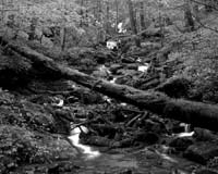
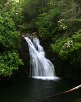
Hike to Kings Fall, photograph, and return to parking lot for appx. 1.2 mile |
| 12:15 - 1:00 PM |
Hike to Spoonauger Falls, photograph, and return to the Chattooga River Trail or the parking lot for appx. .8 mile. We can rest to eat while at the falls or wait until later. |
| At this point, those who just want to enjoy some light hiking may leave the group and enjoy the rest of the day on their own |
| 1:00 - 3:00 PM |
Hike the Chattooga Trail north to the intersection with the East Fork Trail for appx. 2 miles. On the trip north we will be moving slower with elevation gain and taking photos and possibly some fishing. |
| 3:00 - 3:15 PM |
R&R at the log bridge at the intersection |
| 3:15 - 5:00 PM |
Return hike to the parking lot for appx. 2 miles |
| 5:00 - 5:45 PM |
Drive back to Clayton |
| 5:45 - 7:00 PM |
Dinner in Clayton for those who would like to eat there |
| 7:15 - 8:15 PM |
Return to Lula intersection at Hwy 365 to pick up cars |
| 8:30 - 8:45 PM |
Return to Gainesville & Quillians Corner for fueling of carpool vehicles and to pick up cars. |
PLEASE REMEMBER: Time lines are provided as projections and you may move in and out of the schedule as needed, but please let the hike planner known your intentions. Things may move faster or slower than our projections due to many variables. This hike will go rain or shine and will only be canceled for weather conditions which would be a safety hazard to the participants. The bugs will be out by this date, so carry plenty of spray.
Schedule Subject to change. Allow time for the trip to take longer.
|
| Trail Description: |
UPDATE 4-4-07
Just a little clarification regarding the April 28th hike into
the Ellicott Wilderness Area.
Please note: there is NO limit to the number of people that may sign up for this hike from our church group. We may need to split up some if we have more than 12 people in order to not have too many people grouped together which is no problem. We spread out nicely due to our different hiking paces anyway. We will have the radios in order to keep accountability of where our groups are along the trail.
Also, this is a great opportunity for those hikers who only want a short hike. You may hike just to the waterfalls and then call it a day. The waterfall hikes will give you about 2 miles total. If you want to do the short hike only, you
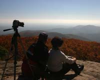
can stay in the area and fish or carry your picnic goodies and just enjoy the river bank. There is a primitive campground area, but it may be full, and it has no facilities so if you want to picnic for the day you should carry all of your supplies. If you enjoy taking pictures, hopefully the weather will be good, the flowers blooming, and the water running strong.
We will only take as many cars into the wilderness area as necessary in order to accommodate everyone. To allow for more parking space, the "meet up" location in Clayton has been moved to the large parking lot of the Ingles' grocery store on the right of Hwy 441 as you go North. We will gather in the lot near the highway and leave any extra vehicles at this location. Since there are no facilities at this location, stop and use restrooms before arriving at Ingles.
If you have any questions regarding this hike, please contact Marsha Conner at: Email or call 770-297-7686.
=========================================
Original Post:
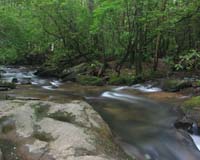
For the hike on April 28, 2007, we will be hiking from the Burrells Ford Campground parking lot north to the intersection of the East Fork Trail. The hike will be divided into two parts. The first part will take us below the campground area to visit King Creek Falls. After backtracking to the parking lot, we will visit Spoonauger Falls. Those who just want a nice short hike in a lovely area may return to the parking lot at this point. From Spoonauger Falls, we will connect to the Chattooga River trail and hike north to the intersection with the East Fork Trail where we will break for R&R. The East Fork Trail is also known as the hatchery trail since it begins at the trout hatcher off Hwy 107 in SC. It is at this intersection that we will get to see a massive log bridge frequently called the "Forty Thousand Dollar" bridge in some circles. This is a very popular area for campers and trout fishers. We will return to the parking area via the same trail.
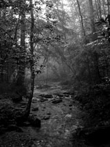
From the hills of Cashiers, NC to Lake Tugalo in GA, the National Wild and Scenic Chattooga River begins as a narrow stream and ends up with Class 4 & 5 rapids. Of the 57 miles this river travels, 40 are wild, 2 miles are scenic, and 15 are recreational. Except for road crossings, motorized vehicles are not allowed within the protective corridor of this river (except at Sandy Ford) and strict guidelines govern recreation, fishing, and camping. The river name of Chattooga has been translated to mean "we cross here" in the Cherokee culture. The river averages a mild 49' per mile drop and the main activities along the upper section of the river (north of Hwy 28) are fishing, hiking, and camping. Two major tributaries flow into the Chattooga in this upper section, the West Fork and the East Fork. The upper section of the river is located in one of the wettest, rainy areas in North America and showers can occur here in minutes and then pass.
Safety is of paramount importance along this river!
Since 1970, over 40 people have died on this river from various types of accidents. The cold water flows extremely fast and you can be trapped in the rocks very easily. Based on its remoteness, there is no way to obtain emergency help quickly. The location of the Chattooga lies in the Nantahala National Forest to the North and in the Chattahoochee National Forest to the South. It is the boundary line between Georgia and South Carolina from the North Carolina border to Lake Tugalo. In the area where all three states meet, is the Ellicott Rock Wilderness area. This is not a state park where rangers are readily available and cell phone coverage may or may not be available.
The ERWA is a beautiful, 9012 acre preserve, designated in 1975 as a unit
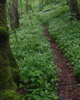
of the National Wilderness System. Elevations in the ERWA range from 2,100' to 3,294' and there are over 50 miles of trails in this section alone. The trails cross and split in several places, so it is important to be very aware of your surroundings.
Named for a surveyor, Major Andrew Ellicott, who was hired in 1809 to try and determine the actual state boundries, a large rock was marked at the exact location where the states joined with "N" on the North side and "G" on the South side. This is the Ellicott Rock. In 1813, another lesser known team of surveyors located the site a few hundred feet away and marked their rock with "LAT 35 AD 1813." This is known as the Commissioner's Rock. The debate continued into 1970 when Governor Jimmy Carter had a commission investigate the boundary issue again.
Reaching the actual location of the Ellicott Rock, in a day hike for the GEC hike group, is a greater distance than we need to attempt at this time for the average of our hikers. There are five different trails that lead to the Rock and we will return to this area in 2008 for more hiking. |
| Notes: |
Walk at your own pace! Try to walk with someone when possible and try to stay in sight or sound of the main group which means the lead hikers may need to slow or stop to let the rear hikers catch up. This is a good reason to carry a whistle on you at all times. Lead hikers should stop at all trail intersections to let everyone gather before moving forward.
If you need a potty break while on the trail, just let someone know you are leaving the trail for a few moments and have that person wait nearby until you return. If you should feel ill or become weak while hiking, let Jeremy or Marsha know immediately. Do not push yourself forward on the trail under adverse conditions. One of us will work with you to maintain your safety. If you have any medical concerns that need to be known, be certain a hiking partner or Jeremy/Marsha know about any issues that could require immediate attention.
Carpoolers should share the cost of fuel when returning to their base location.
If you have any questions regarding the logistics for this hike, please contact Jeremy Landers. If you are signing up to hike or have transportation issues, contact Jeremy Landers. More info on our hiking plans can be found at: www.LandersStudions.com/gechike
PLEASE - DO NOT CONTACT THE CHURCH OFFICE REGARDING THE HIKES. THE CHURCH OFFICE DOES NOT HANDLE OUR PLANS NOR ROSTER FOR THIS ACTIVITY. CONTACT JEREMY OR MARSHA DIRECTLY.
Marsha: Email (770-297-7686) or (678-570-6600)
Jeremy: Email or (770-861-8175 Cell)
Marsha
HIKE AT YOUR OWN PACE - BUT HIKE WITH A PARTNER OR IN SIGHT OR SOUND OF YOUR GROUP FOR SAFETY.
|
| Links & Ref. |
|
| Photos |
|
| Map |
|
| Directions: |
|
| Reservations: |
Yes, Make Reservation with Jeremy /
770-861-8175 or Click Here To Email
Deadline to Sign Up: Wednesday April 25th, 2007
*Special Notice Regarding Hikers Under 18 Years of Age!
|
| Post Trip Review: |
|
|
|