| Trip: |
Coopers Creek Wildlife Managment Area |
| Date: |
Saturday August 9, 2008 |
| Trip Host: |
Marsha Conner |
| Location: |
North of Suches, GA
Yellow Mountain Trail
Cooper Creek Trail
Mill Shoals Creek Trail
Eyes on Wildlife Trail
Directions Below |
| Cost: |
No entrance fee - No parking fee - Carry cash for sharing gas expenses. |
| Difficulty: |
Easy - Moderate |
| Length: |
Hike will be made up of two different loops. First loop is 2.2 miles, second loop is 1.7 miles |
| Blaze: |
First loop:
Yellow Mountain Trail - yellow blaze,
Cooper Creek Trail - blue blaze,
Mill Shoals Creek Trail - orange blaze
FS road #236 - gravel
Second loop:
Eyes on Wildlife Trail - no known blazes |
| Departs From: |
| 9:00 AM |
Gainesville |
| 9:20 AM |
Kroger Thompson Bridge Road (if needed) |
| 9:45 AM |
Dahlonega Walmart (if needed) |
| 10:45 |
Arrive at Coopers Creek Area |
|
Please Let Marsha Conner Know where you will be meeting us. |
|
| Departure Time: |
| Meals: |
Carry mid-day snacks to eat between loops. Early dinner in Dahlonega (Danny's Restaurant) - optional |
| Transportation: |
Car-pool with pre-arranged riderships or drive yourself.
If you need transportation you can post an email to the hike group email list or contact the trip host to see who is going.
(Always be prepared to drive your own vehicle if necessary. If you carpool, fuel costs should be shared.)
|
| GPS Info: |
|
| USGS Quad: |
Mulky Gap |
| Ranger District: |
Brasstown |
| County: |
Union |
| Schedule: |
The projected timeline with distances and events: Due to traffic, & different paces, times are all approximate. If you wish to carpool, let Jeremy or Marsha know or plan on meeting at one of the "meet up" locations shown. Check with your driver to know their plans for the day.
| 9:00 AM |
Depart Gainesville |
| 9:20 AM |
Depart Kroger Thompson Bridge Road (if needed) |
| 9:45 AM |
Depart Dahlonega Walmart (if needed) |
| 10:45 AM |
Arrive at Coopers Creek Area |
| 11:00 AM |
Briefings and begin hiking. |
| 1:30 PM |
Complete First Loop |
|
Break at Campground Area For Approx 30min. |
| 2:00 PM |
Return via road walk to Wildlife trail head |
| 2:15 PM |
Begin Wildlife Loop Trail. |
| 3:20 PM |
Return to parking lot |
| 5:00 PM |
Return to Dahlonega Area approx. 5:00 PM |
PLEASE REMEMBER: Time lines are provided as projections and you may move in and out of the schedule as needed, but please let the hike planner known your intentions. Things may move faster or slower than our projections due to many variables. This hike will go rain or shine and will only be canceled for weather conditions which would be a safety hazard to the participants. Remember to carry plenty of water. Don't forget your bug spray!
Schedule Subject to change. Allow time for the trip to take longer.
|
| Trail Description: |
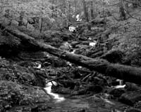
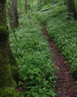
First loop is comprised of 3 trail segments and USFS road #236. From the parking area, you enter on Yellow Mountain Trail and hike appx. one mile, then go left on the short connector, Cooper's Creek Trail for appx. 0.6 mile, then go left on the Mills Shoal Creek Trail for appx. 0.7 mile. This will bring you out at the Cooper's Creek Campground and USFS road #236. Appx. 0.2 back up the FS road is our parking lot. This first loop is all wooded with old growth forest, some small streambeds and has hills. It is rated as moderate.
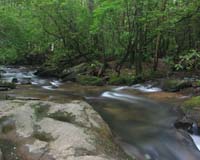
Second loop is one trail which begins and ends at our parking lot. It is basically level and runs beside Cooper's Creek for the about 0.5 mile. It is rated as easy.
|
| Notes: |
The Cooper Creek Wilderness Area is part of the Chattahoochee/Oconee National Forest Area and has a well developed recreation area of trails, campgrounds, and fishing holes. It is accessible by regular passenger vehicles although USFS road #236 can be muddy after heavy rains. This is a gravel road with its fair share of potholes.
Feel free to take water shoes/swim wear if you want to wade or get wet in the creek at the parking lot.
On the way back to Gainesville, those who would like to get an inexpensive and early dinner are invited to stop at Danny's Restaurant on the south side of Dahlonega. This is an optional part of the trip.
Be sure to carry a 4-pack of AA batteries for the radios.
Please let Marsha know your plans as you arrange them for coordination purposes.
Please let Marsha know if you plan to drive alone, need a ride, or plan to dine afterwards.
===============================================
Walk at your own pace! Try to walk with someone when possible and try to stay in sight or sound of the main group which means the lead hikers may need to slow or stop to let the rear hikers catch up. This is a good reason to carry a whistle on you at all times. Lead hikers should stop at all trail intersections to let everyone gather before moving forward.
If you need a potty break while on the trail, just let someone know you are leaving the trail for a few moments and have that person wait nearby until you return. If you should feel ill or become weak while hiking, let Jeremy or Marsha know immediately. Do not push yourself forward on the trail under adverse conditions. One of us will work with you to maintain your safety. If you have any medical concerns that need to be known, be certain a hiking partner or Jeremy/Marsha know about any issues that could require immediate attention.
Carpoolers should share the cost of fuel when returning to their base location.
If you have any questions regarding the logistics for this hike, please contact Marsha Conner or Jeremy Landers. If you are signing up to hike or have transportation issues, contact Jeremy Landers. More info on our hiking plans can be found at: www.LandersStudions.com/gechike
PLEASE - DO NOT CONTACT THE CHURCH OFFICE REGARDING THE HIKES. THE CHURCH OFFICE DOES NOT HANDLE OUR PLANS NOR ROSTER FOR THIS ACTIVITY. CONTACT JEREMY OR MARSHA DIRECTLY.
Marsha: Email (770-297-7686) or (678-570-6600)
Jeremy: Email or (770-861-8175 Cell)
Marsha
HIKE AT YOUR OWN PACE - BUT HIKE WITH A PARTNER OR IN SIGHT OR SOUND OF YOUR GROUP FOR SAFETY.
|
| Special Note: |
Camp Frank D. Merrill an Army Ranger camp is located a few miles from where we will be hiking. From time to time they conduct training exercises in this area. That said, don't be alarmed if you hear gunfire as they are only shooting blanks not live ammunition. We have had several hikes in this area and have yet to encounter a ranger. |
| Links & Ref. |
Visit www.georgiahikes.com for trail information. Note we are only hiking portions of some trails.
Cooper Creek Area Info From Sherpaguides.com
Area Campgrounds
Cooper Creek Campground
Deep Hole Campground
Mulky Campground |
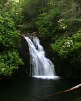
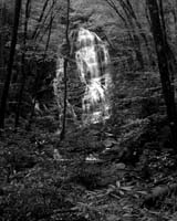
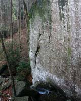
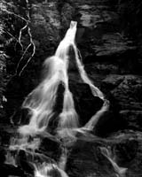
| Photos |
|
| Map |
|
| Directions: |
Take 60 North out of Dahlonega to Suches.
Then, 19 miles North of Suches, turn right on
Cavendar Gap Road. Go 0.8 mile and turn left
on USFS road # 236. Go 2.3 miles to the first
bridge and the parking lot is on your right. |
| Reservations: |
Yes, Make Reservation with Marsha /
770-861-8175 or Click Here To Email
Deadline to Sign Up: Wednesday August 6, 2007
*Special Notice Regarding Hikers Under 18 Years of Age!
|
| Post Trip Review: |
|