| Cancelation Note: |
TRIP CANCELED
Based on the latest combination of weather forecasts from
TV, NOAA, and two other weather sites, the Chattooga River
hike will be officially canceled as a Grace Church parish activity
for Saturday, May 3, 2008.
The latest reports limit the threat of severe and/or tornadic
weather for Rabun County, but indicate up to 1.5" of heavy rain
in at least two major sweeps - one of which would be entirely
during our hiking period on the trail. These rain showers could
be accompanied with some lightening and the possibility of hail.
Periodic rain showers would be in the area throughout the day,
however light or heavy. These conditions are not favorable for
a safe nor enjoyable day of hiking.
I certainly regret having this hike canceled for the second time;
2008 has proven to be a challenging year for weather and hiking,
but we do need the rain - just the rain.
We will keep this hike on the books and try to work it in at
another time this year. Enjoy your week-end.
Marsha |
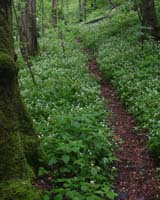
This is a make-up date for the rec hike we had to cancel in March due to weather conflicts. It will be the same hike we had planned for March walking a section of the Chattooga River
trail (Hwy 28 bridge southbound). This will be a timed hike of approximately 4 hours plus breaks with an out and back pattern. This trail is easy to moderate and is close to the river in some spots.
This is a day trip event which takes us into the wet and beautiful Rabun County and to the GA/SC state line.
Information below has been edited to reflect the May 3rd trip. |
| Trip: |
Portion of the Chattoga River Trail |
| Date: |
May 3, 2008 |
| Trip Host: |
Marsha Conner |
| Location: |
Outside of Clayton Ga. |
| Cost: |
Carry cash for fuel sharing, parking & dinner. |
| Difficulty: |
Easy - Moderate |
| Length: |
We will hike a total of abou 4 hours for the round trip out & back hike. |
| Blaze: |
White Diamond |
| Departs From: |
| 9:45 AM |
Stage at J&J Grocery, Limestone Parkway Gainesville |
| 10:00 AM |
Depart J&J Grocery, Limestone Parkway Gainesville |
|
If somone needs to meet us at Ingles in Clayton Please Let Marsha Conner Know |
|
| Departure Time: |
| Meals: |
Carry any snacks you may want for the afternoon along the trail. We will stop to snack and rest as conditions warrant.
Dinner following optional. Please let Marsha know if you are doing dinner or not so she can make plans. |
| Transportation: |
POV's with carpooling, or drive on own. If you need transportation you can post an email to the hike group email list.
(Always be prepared to drive your own vehicle if necessary. If you carpool, fuel costs should be shared.)
|
| GPS Info: |
|
| USGS Quad: |
Satolah - Rainy Mountain |
| Ranger District: |
|
| Schedule: |
The projected timeline with distances and events: Due to traffic, & different paces, times are all approximate. If you wish to carpool, let Jeremy or Marsha know or plan on meeting at one of the "meet up" locations shown. Check with your driver to know their plans for the day.
| 9:45 AM |
Meet at J&J Foods, Limstone Parkway, Gainesville |
| 10:00 AM |
Depart J&J Foods |
| 11:30 AM |
Meet in the parking lot of Ingles Grocery Store, Clayton Ga. (Down near the highway)
We will reduce the number of vehicles and then drive out hwy 28 to Russell Bridge to park for the hike. Note: There will be no "Off Pavement" travel on this trip! |
| 12:15 PM |
Arrive at Russell Bridge, park, prepare to hike. |
| 12:30 PM |
Depart on Chattoga River Trail South of Hwy 28 |
| 2:30 PM |
Snack Break & Begin Return Hike |
| 4:30 PM |
Meet back at vehicles at Russell Bridge |
| 5:15 PM |
Return to Ingles to pick up vehicles and depart area. |
PLEASE REMEMBER: Time lines are provided as projections and you may move in and out of the schedule as needed, but please let the hike planner known your intentions. Things may move faster or slower than our projections due to many variables. This hike will go rain or shine and will only be canceled for weather conditions which would be a safety hazard to the participants. Remember to carry plenty of water. Don't forget your bug spray!
Schedule Subject to change. Allow time for the trip to take longer.
|
| Trail Description: |
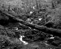
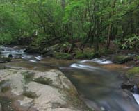
This section of trail provides several opportunities to be fairly close to the river and to enjoy a comfortable trail hike with only moderate terrain changes and numerous level sections.
River is open for trout fishing with proper license. Limited access points along the trail to the river.
|
| Notes: |
From Marsha's Email. Feb 19, 2008
(Edited for May 3rd Hike)
The Ma 3, 2008 recreational hike will take us to another section of the Chattooga River.
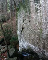
This river, designated as one of America's "wild and scenic" rivers begins in the Highlands of North Carolina, and ends as Tugaloo River. It provides the borders for the states of Georgia and South Carolina for many miles and provides hiking experiences ranging from extreme and difficult in the northern sections to mild and easy in the southern sections. With very limited access by vehicle, the trail sections along the river corridor provide some of the only means to see the river unless you are on the water rafting in the lower sections.
As a matter of interest, the river sections north of Hwy 28 intersection are still protected
from kayaking and rafting although this matter is still in court as the result of a law suit. The rulings for this law suit should be known this spring or summer as the National Forest Service attempts to work out some form of arbitration between the groups. Many private river runners put in near Hwy 28 while most of the commercial operators put in near Hwy 76 lower down the river.
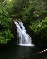
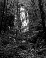
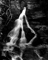
Last year, we visited the Burrells Ford section of the river in the northern third of its run.
Though we spent most of our time seeing waterfalls, it was a good chance to get a real taste of the beauty of this river and the forest surrounding it. Later on, we will return to
this section and hopefully make it to Ellicott’s Rock as well as the “cliffs” section near
Highlands, NC.
For our hike on May 3rd, we will start at the Hwy 28 crossing with the river at Russell Bridge and hike south on an out and back pattern for a "timed" hike. There is limited parking at the Russell Bridge so we will stage in Clayton before heading to the bridge.
This section of trail provides several opportunities to be fairly close to the river and to enjoy a comfortable trail hike with only moderate terrain changes and numerous level sections. As best I can determine from the GaDNR fishing regulations, this section of the Chattooga River is a year round section for fishing so feel free to pack a reel and your bait and take some time to try your luck. I will check and confirm the fishing regs.
This trip is a “GO” unless weather conditions are dangerous for personal safety.
If you are still trying out some new equipment or shoes, this would be a good hike to see how things feel. Those who wish to go to dinner after the hike are welcome to stay and those who rather head back to Gainesville may feel free to do so.
REMINDERS:
If you need a ride, let Marsha know so we can coordinate drivers/riders/pups.
If you ride with someone, know ahead of time if they plan to eat in the local area
before returning to Gainesville.
If you ride with someone, plan on sharing fuel cost (cash please).
Do not leave anything of value in your vehicle while parked at Ingles or Russell Bridge.
If you plan on fishing, be sure to have a valid fishing license and trout stamp if needed.
Be sure to carry some form of photo ID on your person while hiking.
Be sure to carry a 4-pack of AA batteries for the radios.
As always, pack it in and pack it out – we leave no trace except our footsteps.
Please let Marsha know your plans as you arrange them for coordination purposes.
Please let Marsha know if you plan to drive alone, need a ride, or plan to dine afterwards.
===============================================
Walk at your own pace! Try to walk with someone when possible and try to stay in sight or sound of the main group which means the lead hikers may need to slow or stop to let the rear hikers catch up. This is a good reason to carry a whistle on you at all times. Lead hikers should stop at all trail intersections to let everyone gather before moving forward.
If you need a potty break while on the trail, just let someone know you are leaving the trail for a few moments and have that person wait nearby until you return. If you should feel ill or become weak while hiking, let Jeremy or Marsha know immediately. Do not push yourself forward on the trail under adverse conditions. One of us will work with you to maintain your safety. If you have any medical concerns that need to be known, be certain a hiking partner or Jeremy/Marsha know about any issues that could require immediate attention.
Carpoolers should share the cost of fuel when returning to their base location.
If you have any questions regarding the logistics for this hike, please contact Marsha Conner or Jeremy Landers. If you are signing up to hike or have transportation issues, contact Jeremy Landers. More info on our hiking plans can be found at: www.LandersStudions.com/gechike
PLEASE - DO NOT CONTACT THE CHURCH OFFICE REGARDING THE HIKES. THE CHURCH OFFICE DOES NOT HANDLE OUR PLANS NOR ROSTER FOR THIS ACTIVITY. CONTACT JEREMY OR MARSHA DIRECTLY.
Marsha: Email (770-297-7686) or (678-570-6600)
Jeremy: Email or (770-861-8175 Cell)
Marsha
HIKE AT YOUR OWN PACE - BUT HIKE WITH A PARTNER OR IN SIGHT OR SOUND OF YOUR GROUP FOR SAFETY.
|
| Links & Ref. |
|
| Photos |
|
| Map |
|
| Directions: |
Call Marsha For Directions |
| Reservations: |
Yes, Make Reservation with Jeremy /
770-861-8175 or Click Here To Email
Deadline to Sign Up: Wednesday June 6, 2007
*Special Notice Regarding Hikers Under 18 Years of Age!
|
| Post Trip Review: |
|
|
|