| Data Updated: |
Friday, May 17, 2013 8:29:53 PM |
| Status: |
Confirmed
|
| Weather: |
Clayton, Ga 10 Day Forecast
|
| Trip: |
Three Forks Trail
|
| Date: |
June 29, 2013
|
| Trip Host: |
Marsha Conner
|
| Location: |
Three Forks Trail,
Chattahoochee National Forest off Warwomen Road in Rabun County, Georgia |
| Park Contact Info: |
NA |
| Cost: |
Bring cash to share in fuel costs, and day use fees.
Please remember that it is our group policy to share the cost of fuel and parking expenses when carpooling.
There is no parking fee at this location for June 29, 2013.
|
| Difficulty: |
Easy to Moderate |
| Length: |
3 Miles |
| Blaze: |
Diamond |
| Departs From: |
Grace Church Kitchen Parking Lot
Corner Cafe' (If needed) |
| Departure Time: |
8:15 Meet at Grace
8:30 Depart Grace
8:50 Meet at Corner Cafe' (If Needed)
9:00 Depart Corner Cafe' |
| Meals: |
Bring a trail lunch or snack.
If you wish to stop in Clayton and eat before returning toGainesville, please let Marsha know when you sign up. If you carpool, please check with your driver to know their intentions. We can stage cars in Clayton at the Ingles parking lot as needed for accommodations after the hike.
|
| Additional Equipment: |
For this hike, you may want to add water shoes to your pack equipment and a towel – just in case. Also, add bug spray and something to sit upon on the ground.
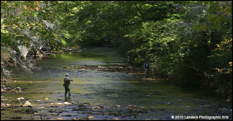
This is a trout fishing stream downstream from the falls, so if you decide to explore the bottom of the gorge area, you can fish with the proper licenses.
We will have time to spend at least an hour or so at the end of the trail to enjoy this location, so plan on a relaxing visit on this hike. Don’t forget your cameras as this should be a lovely area to photograph. This will be a rather slow, peaceful day of hiking and exploring in the forest and along the trail.
|
| Transportation: |
POV's with carpooling, or drive on own. If you need transportation you can post an email to the hike group email list.
(Always be prepared to drive your own vehicle if necessary. If you carpool, fuel costs should be shared.)
|
| GPS Info: |
|
| USGS Quad: |
|
| Ranger District: |
|
| Schedule: |
This schedule is a work in progress. Please check back later as we firm up the details.
|
|
|
Saturday
June 29 |
|
| 8:15 AM |
Meet up at Grace Episcopal Church Kitchen Parking Lot |
| 8:30 AM |
Depart Grace Parking Lot |
| 8:50 AM |
Meet up at Corner Cafe', Lula (Intersection of Hwy 365 & Hwy 52) |
| 9:00 AM |
Depart Corner Cafe' |
| 9:45 AM |
Break at Race Trac in Clayton (Hwy 441 on Right) |
| 10:00 AM |
Depart Race Trac for trailhead
Stage Vehicles at Ingles if necessary |
| 11:00 AM |
Safety briefing and start hike |
| 12:30 PM |
Arrive at trail end - rest and relaxation |
1:30 PM /
2:00 PM |
Start Return Hike |
3:30 PM /
4:00 PM |
Arrive back at trailhead |
4:30 PM
5:00 PM |
Arrive back in Clayton |
5:30 PM /
6:00 PM |
Arrive back in Gainesville |
| Optional |
Stay for dinner in Clayton |
|
|
*Be sure and check with your driver as to what their plans will be if you are a rider.
All times are approximate and are subject to change without notice! Direction of travel is subject to change as well. |
| Trail Description: |
This will be an out & back route with each leg being approximately 1.5 miles. The official trail is marked with diamond blazes.
The trail is graded as an easy to moderate hike. At the end of the marked trail, we will reach a location where three bodies of water all come together to form the West Prong of the Chattooga River. There is an overall elevation drop of 540’ going in and an elevation gain coming back to the trail head. There is a miniature gorge at the end of the trail where we will rest and relax for an extended period of time on this hike and explore the area. If you have some billy goat in you that day, you may want to go to the bottom of the falls which is an off trail walk of about .2 that is rated very strenuous. This will not be a planned part of our hike for the day but we will check it out upon arrival.
This trail gets its name from the three mountain streams that tumble together at right angles to form the West Prong of the Chattooga River. Those streams are the Holcomb, Overflow, and Big Creek. Holcomb Creek enters from the west, Overflow in the middle, and Big Creek from the northeast.
As the trail begins, it climbs very gently for about .3 mile along a tree lined route. Then, it begins a steady decent to where Holcomb Creek begins. At .7 mile, we cross the Chattooga Wild and Scenic River boundary line. Nearer the end of the trail, at the 1.0 mile mark, we enter a T intersection with an old road bed. Here, we turn left and descend at a more moderate rate for another .2 mile to the big rock bluff overlooking the small gorge. This is the end of the official blazed trail. The remaining .2 - .3 mile section is the billy goat climb down into the bottom level of the falls and this is a section we can consider individually after we survey the conditions that day. We will enjoy our extended time of R&R from the rock bluff at the top of the falls though.
|
| Trip Notes: |
|
| In Case Of Emergency Forms (ICE): |
Please be sure your ICE form emergency contact information is up to date. The only part of this form that is required to be completed is the personal contact info for each hiker. We think it would be wise to provide the medical information, but that is optional for each hiker. These forms and the envelope they will be sealed in are bright yellow. If you have not turned in a new ICE form, you will need to do so before you hike. You may contact Marsha or Jeremy to obtain a form. Please have these forms filled out before we meet to hike. You can turn them in at the hike site, but it will be best to have them filled out before we gather to hike. |
General
Notes: |
Walk at your own pace! Try to walk with someone when possible and try to stay in sight or sound of the main group which means the lead hikers may need to slow or stop to let the rear hikers catch up. This is a good reason to carry a whistle on you at all times. Lead hikers should stop at all trail intersections to let everyone gather before moving forward.
If you need a potty break while on the trail, just let someone know you are leaving the trail for a few moments and have that person wait nearby until you return. If you should feel ill or become weak while hiking, let Jeremy or Marsha know immediately. Do not push yourself forward on the trail under adverse conditions. One of us will work with you to maintain your safety. If you have any medical concerns that need to be known, be certain a hiking partner or Jeremy/Marsha know about any issues that could require immediate attention.
Carpoolers should share the cost of fuel when returning to their base location.
If you have any questions regarding the logistics for this hike, please contact Jeremy Landers. If you are signing up to hike or have transportation issues, contact Jeremy Landers. More info on our hiking plans can be found at: www.LandersStudions.com/gechike
PLEASE - DO NOT CONTACT THE CHURCH OFFICE REGARDING THE HIKES. THE CHURCH OFFICE DOES NOT HANDLE OUR PLANS NOR ROSTER FOR THIS ACTIVITY. CONTACT JEREMY OR MARSHA DIRECTLY.
HIKE AT YOUR OWN PACE - BUT HIKE WITH A PARTNER OR IN SIGHT OR SOUND OF YOUR GROUP FOR SAFETY.
|
| Links & Ref. |
|
| Photos |
|
| Map |
http://georgiahike.web105.discountasp.net/maps/bin/three_forks_trail.gif
|
| Directions: |
View Larger Map |
| Hike Reservations: |
Required
Deadline: .
Marsha Conner
*Special Notice Regarding Hikers Under 18 Years of Age!
|
| Post Trip Review: |
|